
To see the Western Ghats only from the window of a moving vehicle is to look at a masterpiece with your eyes closed. Older than the majestic Himalayas, this ancient mountain chain is a globally recognized UNESCO World Heritage site and an absolute biological superpower, harboring ecosystems found nowhere else on Earth. It is a landscape defined by sharp, soaring ridges, hidden river valleys, and precipitous cliffs that trap the monsoon clouds, orchestrating a relentless, million-year-old cycle of life.
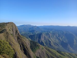
At the absolute crown of this system lies the central massif block of Munnar. This is not just a destination; it is an incredible geographic labyrinth of ‘sky-islands’—isolated granite peaks surrounded by an ocean of moving mist, where prehistoric cloud forests (Sholas) and undulating alpine grasslands interlock in perfect, dynamic balance. This unique topography creates an unparalleled frontier for the high-altitude trekker and the serious naturalist. Out on these exposed paths, the mountain air carries the sharp scent of wild lemongrass, the weather changes within a matter of minutes, and every ridge line crossed opens into an ever-captivating, infinite view.
Yet, a profound tragedy of modern exploration occurs here every day. The vast majority of travelers who ascend these hills pack Munnar into a brief, mechanical two- or three-night stay as a minor checklist item on a standard, rushed vacation itinerary. They navigate the predictable, commercialized loops—snapping a quick photo at a crowded reservoir or a tea museum—and leave believing they have witnessed the mountains.
In their haste, they completely miss the true, unfolding depth of this land. They miss the quiet, timeless rhythm of a perennial love story written between the soaring peaks and the heavy cloud banks that blanket them. A brief weekend stay cannot reveal the exclusive, hyper-endemic flora and fauna that require patience and distance to encounter: the mass synchronized blooms of the Neelakurinji that paint entire massifs in purple, the elusive Nilgiri Tahr stepping effortlessly across sheer vertical rock faces, or the rare birds whose calls echo through the ancient forest canopies.
The true character of these mountains was understood deepest by the pioneering explorers who abandoned the low-altitude comfort zones to map the high ridge-lines on foot. Among them, General Douglas Hamilton—famed as the definitive pioneer of the High Ranges—looked out across these staggering, mist-laden plateaus in the 1860s while conducting early mapping surveys and remarked:
“Surpassingly grand and incomparably beautiful… this is far beyond my power to describe and must be seen to be appreciated.”
Hamilton’s logs did not just map the terrain; they recorded an overwhelming sense of awe, identifying these unique high-altitude expanses as an unmatched alpine paradise that demanded deep humility, endurance, and time to truly comprehend.
To experience Munnar through Hamilton’s lens is to realize that these sky-islands cannot be rushed. They demand that you drop the frantic pace of the lowlands, pack a rucksack, and step onto the old trails. These peaks are not a static background for a brief holiday—they are an ancient, sacred wilderness that reveals its secrets only to those who choose to stay, to walk, and to listen.
Understanding this mountain landscape requires looking past the low-altitude valleys to analyze the strict environmental graduations of its high-altitude ridges. Here is the objective geographic, biological, and social breakdown of the seven key peaks that define the structural matrix of the High Ranges.
1. Anamudi: The Peninsular Summit
• Altitude: 2,695 Meters (8,842 Feet). Situated within the core territorial boundary of Eravikulam National Park, it forms the highest elevation in India south of the Himalayas.
• Flora: The summit represents a fully unedited montane Shola-grassland ecotone. Above the 2,000-meter threshold, the terrain is dominated by micro-endemic species including Strobilanthes kunthiana (Neelakurinji), dwarf high-altitude bamboos (Arundinaria), and the critically endangered, prehistoric tree fern Cyathea crinita. Extreme winter frost and intense wind-shear condition the peak, stunting tree growth and yielding highly specialized sub-alpine meadows.
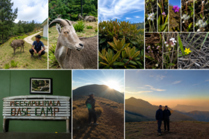
• Fauna: Anamudi is the primary refuge for the largest surviving population of the endangered Nilgiri Tahr (Nilgiritragus hylocrius). The vertical granite faces provide safety for these specialized wild ungulates. The surrounding deep ravines protect lesser-known mammalian predators, including the nocturnal Nilgiri marten, the clawless otter in the upper mountain streams, and solitary leopards operating along the forest boundaries.
• Human Habitat & Context: The core summit is legally classified as an absolute sanctuary, devoid of human settlements. The baseline ridges are monitored by the indigenous Muthuvan tribe. Working as government-recognized forest watchers under conservation frameworks, they navigate these ridges daily to conduct wildlife tracking, remaining the sole human presence on the upper migratory routes.
2. Meesapulimala & Rhodo Valley: The Glacial Amphitheater
• Altitude: 2,640 Meters (8,661 Feet). The second-highest elevation in the Western Ghats, forming a natural, trans-boundary geographic ridge between Kerala and Tamil Nadu, anchored by the high-altitude basin of Rhodo Valley.
• Flora: Characterized by expansive, rolling montane grasslands and deep, wind-sheltered bowls that hold large concentrations of wild Rhododendron (Rhododendron arboreum ssp. nilagiricum). Shielded from the volatile ridge winds, these trees grow to exceptional sizes within the Rhodo Valley inner bowl, producing dense crimson blooms from January to March. The damp floor features boreal mosses, lichens, wild strawberries, and insectivorous Sundews (Drosera).
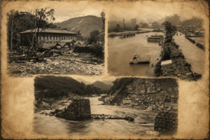
• Fauna: The ridge operates as an active trans-boundary migratory corridor for megafauna. Wild elephant herds ascend these steep grasslands from the Chinnakkanal basin during dry seasons, tracking the high-altitude water tables and perennial streams. The ecosystem additionally supports the Indian Gaur (bison), the endemic Nilgiri Pipit, specialized stream-frogs, and the Black Eagle utilizing intense thermal updrafts.
• Human Habitat & Context: Apart from basic forest department monitoring posts and minimalist low-impact eco-shelters, the upper ridges are unpopulated. The lower trails connect with the historical, high-altitude estate lines of Kolukkumalai, where generations of Tamil-origin tea workers inhabit stone-walled labor quarters, operating along the steep agricultural gradients.
3. Kolukkumalai Peak: The Eastern Precipice
• Altitude: 2,400 Meters (7,874 Feet). A sharp, linear granite ridge offering a near-vertical drop into the lowlands of the Theni district of Tamil Nadu.
• Flora: Displays an abrupt transition zone where the upper limits of high-altitude orthodox tea cultivation converge with ancient, moss-draped Shola fragments. Wild orchids—particularly species of Aerides and Coelogyne—cling to the gnarled bark of old-growth trees, while dense wild lemongrass anchors the exposed rock faces.
• Fauna: A critical habitat for high-altitude avifauna. The canopies hold the Nilgiri Wood Pigeon, the endemic Kerala Laughingthrush, and the White-bellied Blue Flycatcher. Nocturnal monitoring records frequent movements of the Asian Palm Civet and the Indian Crested Porcupine along the rocky gaps.
• Human Habitat & Context: The social landscape is strictly defined by an active plantation community. Traditional estate workers navigate terrain gradients exceeding 45 degrees for harvest cycles. The settlement is isolated from the urban valley centers below by persistent cloud cover, operating under traditional plantation schedules without modern urban infrastructure.
4. Chokramudi: The Southern Sentinel
• Altitude: 2,180 Meters (7,152 Feet). An isolated, pyramid-shaped granite massif positioned in the southern sector of the High Ranges, overlooking the Bison Valley plateau.
• Flora: The mountain shows a distinct altitudinal graduation. The lower slopes hold dense evergreen moist forests, which rapidly transition into rocky sub-alpine grasslands near the crest. Endemic balsams (Impatiens), wild ginger, and specialized varieties of high-altitude grasses occupy the narrow fissures in the granite face.
• Fauna: Due to its isolated position from the central high block, Chokramudi functions as a vital seasonal sanctuary. Sambar deer, barking deer, and wild boars utilize the dense forested base, while the upper rocky structures are tracked by hunting packs of Asiatic Wild Dogs (Dholes) and solitary leopards.
• Human Habitat & Context: The base of the mountain is flanked by old spice-growing homesteads and independent agricultural settlers in Bison Valley and Pothemmedu. These communities practice small-scale agro-forestry, growing cardamom and pepper, creating a steady buffer zone between the wilderness and commercial centers.
5. Letchmi Hills Peak: The Montane Ridge
• Altitude: 1,950 Meters (6,398 Feet). A prominent high-altitude ridge line running northwest of Munnar town, commanding direct views of the Anamudi massif.
• Flora: The topography consists of an unbroken succession of rolling montane grasslands, divided by narrow ribbons of old-growth Shola forest tucked into the protected folds of the mountain. Endemic ferns, wild balsams, and resilient mountain grasses form a thick carpet that shifts in color with seasonal monsoon precipitation.
• Fauna: The open grassland plateaus serve as steady foraging grounds for Sambar deer herds and wild boars. The persistent ridge currents support several birds of prey; the Common Kestrel, Crested Serpent Eagle, and Black-winged Kite use the updrafts to monitor the grassland floor for small mammals.
• Human Habitat & Context: The lower slopes preserve old colonial-era bridle paths and historic tea divisions. Small, self-contained estate worker hamlets are situated along the lower boundaries of the ridge, maintaining a quiet lifestyle closely linked to the seasonal agricultural cycles of the surrounding tea divisions.
6. Top Station Peak: The Historic Boundary Terminus
• Altitude: 2,200 Meters (7,218 Feet). A sharp geographic overlook located at the highest point of the interstate highway corridor, historically marking the terminus of the Kundala Valley mono-rail system.
• Flora: The peak’s cliff faces mark an abrupt boundary where warm air rising from the plains of Tamil Nadu collides with cold montane currents. This constant thermal mixing creates a specialized cloud-forest environment rich in moisture, where tree trunks are densely layered with lichens, club-mosses, and epiphytic ferns.
• Fauna: The sheer rock walls provide vital nesting ledge environments for apex raptors, including the Peregrine Falcon and the Shaheen Falcon. The lower valley canopies support the Malabar Giant Squirrel (Ratufa indica), which relies on wild forest nutmeg and native tree seeds and the endangered Nilgiri Langur (Trachypithecus johnii). It is famous for its glossy black body and striking golden-brown fur on its head.
• Human Habitat & Context: The locality carries an old industrial footprint from early tea-transportation systems. The modern settlement consists of a small, bilingual community of farmers and traders from both Kerala and Tamil Nadu, living along the border trail and operating small homesteads and local tea stalls near the historical transport terminus.
7. Pettimudi Peak (near Adimaly): The Lion Head Western Outpost
• Altitude: 1,300 Meters (4,265 Feet). A dramatic, monolithic granite peak situated near Adimaly, forming the steep western boundary of the High Range plateau. Far from the Kanan Devan hills it looks literally like an ancient black granite Indian sphinx.
• Flora: Reflecting its lower elevation, Pettimudi contains a highly diverse sub-montane and evergreen forest cover. The sheer granite rock walls support drought-resistant grasses, wild cycads, and dense thickets of wild reeds (Ochlandra travancorica, locally known as Eeta) that thrive in the narrow rocky fissures.
• Fauna: The dense forest tracts around Adimaly serve as a historical habitat for the Lion-tailed Macaque, Malabar Giant Squirrel, and an array of amphibians. Solitary leopards, barking deer, and various nocturnal civet species and a few herds of wild elephants use the thick baseline cover as a migratory refuge when moving between the lower valleys and the high plateau.
• Human Habitat & Context: The area is surrounded by long-standing forest-dwelling tribal communities and early high-range agricultural settlers, primarly the Mannan tribes. The human landscape is characterized by small homesteads cultivating black pepper, cocoa, and root tubers, and in recent years primarly cardamom; entirely independent of the centralized tea plantation networks.
The Ecological Matrix
Analyzing these seven peaks—from the guarded sub-alpine fields of Anamudi to the lower evergreen outpost of Pettimudi near Adimaly—reveals that the mountain landscape cannot be understood as a uniform destination. Each massif forms an independent ecological unit, defined by its own altitudinal graduations, distinct weather patterns, specialized wildlife communities, and specific human histories. These sky-islands form an intricate alpine labyrinth where the natural and social fabrics are completely inseparable from the physical geography of the land.